|
Surface downward shortwave radiation derived from ISCCP
DX
SW↓ Radiative fluxes were produced over the Atlantic Ocean for about
ten years based on ISCCP DX at 0.5°
spatial resolution at daily time scale (Figure 1).
They are
produced by UMD/SRB model Ver3.3.3 from Jan 1, 2003 to Dec 31, 2005.
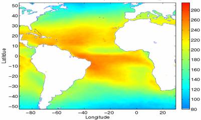 | |
Figure 1. Annual mean surface downward shortwave flux from UMD/SW_DX for
2004 |
A preliminary evaluation was conducted against buoys from the
Prediction and Research Moored Array in the Atlantic (PIRATA) array
(Servain et al., 1998) (Figure 2).
 |
|
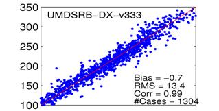
Figure 2. Evaluation of UMD/SW_DX product against ground
observations using about 30 BSRN stations distributed globally.
Period: monthly means for 2003-2005 |
Surface
downward shortwave radiation derived from MODIS
The MODIS data are
at
10
spatial resolution at daily time scale. The Moderate
Resolution Imaging Spectro-radiometer (MODIS) instrument onboard the
Terra and Aqua satellites is a sensor with 36 spectral bands with an
onboard calibration of both solar and infrared bands. The wide
spectral range (0.41-14.24 µm), frequent global coverage (one to
two days revisit), and high spatial resolution permit global
monitoring of atmospheric profiles, column water vapor amount,
aerosol properties, and clouds, at higher accuracy and consistency
(King et al., 1993) allowing to derive radiative fluxes at global
scale from the same instrument. An inference scheme (Wang and
Pinker, 2009) to estimate surface, TOA, and atmospheric shortwave radiative fluxes has been developed and implemented with MODIS
products as available at 10 spatial resolution twice a day (Terra
and Aqua). Results have been evaluated over the Atlantic ocean
(Figure 3) (Pinker et al., 2009).
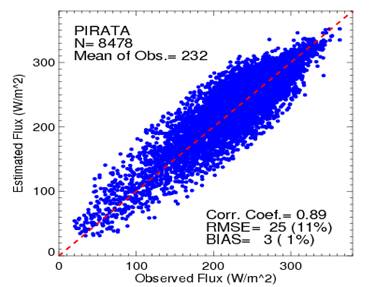 | |
Figure
3. Daily mean surface SW flux estimated by UMD/SW_MODIS
against PIRATA buoys from January 1, 2003 to December
31, 2005 (cases eliminated: 1.1%). |
Evaluation of various SW radiative fluxes
| |
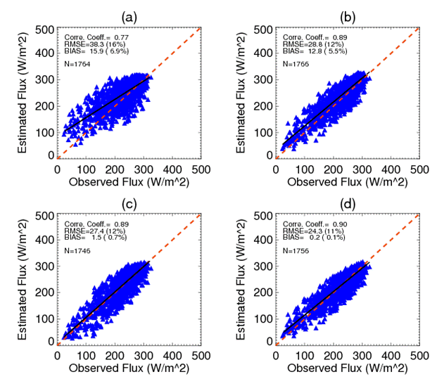
Figure 4. Evaluation
of daily surface downward SW radiative fluxes from satellite estimates against
PIRATA buoys for 2004: a) WHOI; b): UMD/SW_DX; c): UMD/SW_MODIS); d): UMD/SW_DX
bias corrected (black line is the best fit line). |
Surface
Downward Longwave Radiation derived from ISCCP DX
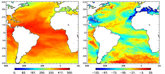 | |
Figure 5. Left: downward LW;
Right: LW net for the period of January 3-9,
2005 from UMD/LW_DX. |
To compute upwelling LW, initially, SST from available sources (such as Reynolds et al.
(2007)) have been used to be subsequently replaced by a newly
developed algorithm for SEVIRI to be implemented at high resolution
and represent the diurnal cycle.
Longwave Radiation derived from MODIS
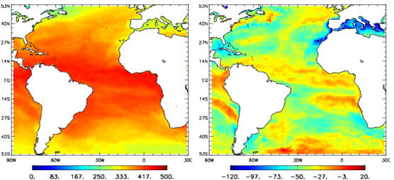 | |
Figure 6. Left: downward LW;
Right: LW net for the period of January 3-9,
2005 from UMD/LW_MODIS. |
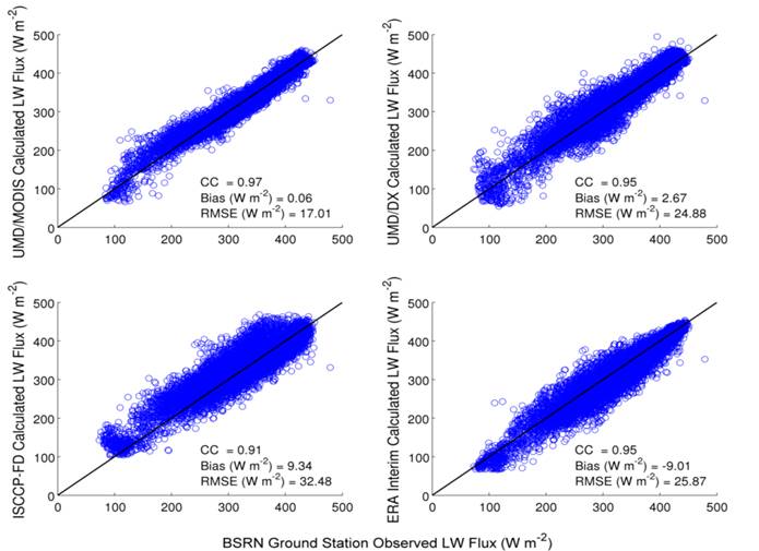
Evaluation of LW radiative fluxes
Evaluation of the LW fluxes as derived from MODIS, ISCCP_DX/UMD,
ISCCP-FD and ERA Interim for the year 2004 is shown in
Figure 9. Evaluation
against ocean observations was not possible due to lack of data.
|
 |
|
Figure 7. Evaluation of the LW fluxes as derived from: 1)
MODIS, 2) ISCCP_DX/UMD, 3) ISCCP-FD and 4) ERA interim
for the year 2004. |
Back to Results
|