|
Collaborative Research Atlantic Air-Sea fluxes from satellites, their variability and analysis of ocean models Department of Atmospheric and Oceanic Science University of Maryland, College Park |
Radiative Fluxes
| Background | |
|
|
Approach |
|
|
Data Sets Used |
|
|
Results |
|
|
Available Data |
|
|
Publications |
|
|
Outreach Activity |
|
|
Acknowledgements |
|
|
Contacts |
|
|
References |
| Back to Front Page | |
|
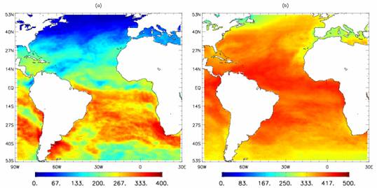
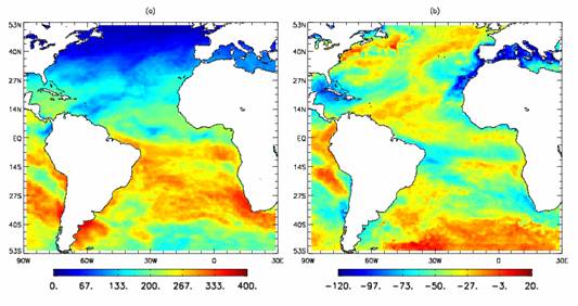
Radiative fluxes - SW Strategy in developing information on radiative fluxes: 1) obtain information at longer time scales to match the period of heat flux estimates; 2) obtain the best available information. The following steps were taken: 1. Produce and evaluate long term estimates using historical satellite data. Used are various International Satellite Cloud Climatology Project (ISCCP) data with updated schemes for improved treatment of aerosols. 2. Produce and evaluate shorter term estimates using observations from improved satellite systems such as MODIS on Terra and Aqua and the SEVIRI on METEOSAT-8 to establish limits on the accuracy of the historic data. The year 2004 was selected since both METEOSAT-7 (a 3 channel instrument) and METEOSAT-8 (a 12 channel instrument) were simultaneously operational. METEOSAT-7 provides the link to the long term data sets (ISCCP D1 and DX). Data from MODIS are produced for the entire 3-year period. Radiative fluxes-LW The longwave strategy followed the shortwave one, namely, fluxes were produced both from the ISCCP DX and MODIS observations but not from METEOSAT-8.
Net Radiative fluxes Net SW and net LW data
sets have been produced and total net radiative fluxes were computed
and are provided at this web site.
Back to Results |
||||
|
|