For quality assurance of this product, access to the raw satellite observations used is necessary. Examples for such needs:
testing of improvements in the inference scheme
reprocessing of the products in case problems arise in the routine operation
NOAA/NESDIS does not archive the raw GOES satellite data. At the completion of the operational processing of the radiative fluxes the data are deleted. To meet the needs for the availability of the satellite data, archiving of the GOES data was initiated in 2001 in collaboration with the University of Maryland Institute for Advanced Computer Studies (UMIACS, Dr. Joseph JaJa, Director), within the Global Land Data Facility (GLDF)(Dr. John Townshend, PI). GLDF is a member of NASA's Earth Science Information Partnership Federation (ESIP) program and, as such, is responsible for the development, distribution, and archiving of novel Earth Science products and satellite imagery.
An example for the use of the archived GOES data follows:
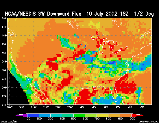
On July 10, 2002, a poor agreement between surface observations in the northern Unites States and the operational satellite estimates of surface downward shortwave radiative flux was identified (top figure, below). The NOAA/NESDIS operational model uses only one of the four channels of GOES data to determine cloud cover, which is used as input to the radiative transfer algorithm.
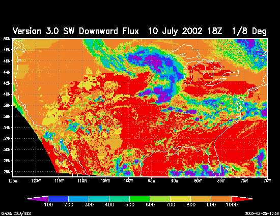
The middle figure shows the surface downward shortwave radiative flux computed with data from the UMIACS archive, using a four-channel cloud screening algorithm (Version 3.0) for the same date and time. The surface downward shortwave radiative fluxes are now smaller in areas of cloud cover when compared to the top figure. As evident, Version 3.0 identified the large cloud system west of the Great Lakes.
The one-channel algorithm has difficulty differentiating between clouds and snow, and thus does not perform as well in snow-covered areas as compared to snow-free areas. Even with the limitations of the one-channel algorithm, it is unusual to miss such an obvious, well-developed cloud feature. Further investigation of this case indicated that in 2002, a software problem was experienced in the operational production that resulted in a failure to update the snow cover fields for the months of March through August 2002. Therefore, the data used to produce the NOAA/NESDIS shortwave fluxes in the top figure assumed a snow cover from February 2002. The one-channel algorithm was unable to detect the large cloud feature because it occurred over a region erroneously considered to be snow-covered.
Middle: Surface downward shortwave flux (W/m**2) with inputs from the UMIACS archive, using an updated four-channel cloud screening methodology (Version 3.0)
Bottom: Actual GOES-8 satellite image for the same time.
|
|
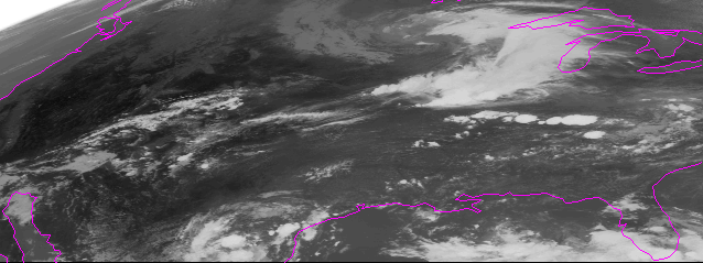
GOES-8 10 July 2002 18Z |
Acknowledgement:
Improved algorithms are being developed in the Department of Meteorology, University of Maryland under a Reprocessing Activity of surface radiative fluxes for the GCIP period of 1996-2000 under grant NAG59916 from NASA to the University of Maryland (R.T. Pinker, PI)
Maintained by Maggie Wonsick
Direct questions and comments to mwonsick@atmos.umd.edu