An Initialization Scheme of Hurricane Models Using the Advanced Microwave Sensing Unit Measurements
Zhu, T., F. Weng and D.-L. Zhang
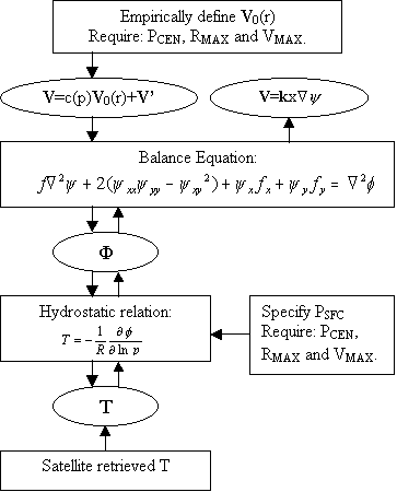
Figure 1. The flow chart of the procedures for a typical bogus scheme starting from top downward, and the procedures for the new scheme starting from bottom upward. Symbols V0, c(p) and V denote the axisymmetric surface wind field, the vertical distribution function and asymmetric components of horizontal winds. See text for the definition of the remaining symbols.
Figure 2. Vertical distribution of the AMSU-A Channels 3-14 weighting function at nadir over land (Adapted from Janssen 1993).
Figure 3. Vertical distribution of the root mean square (RMS) errors of the AMSU-derived temperatures.
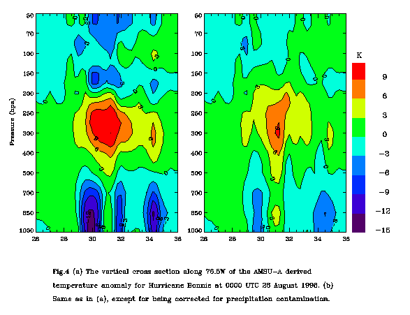
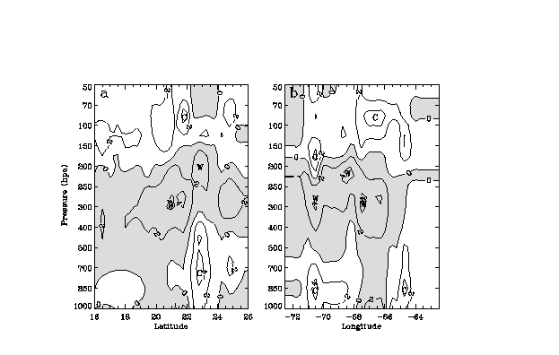
Figure 4. Vertical cross sections of the AMSU-derived temperature anomalies (every 2 0C) associated with Bonnie at 0000 UTC 26 August 1998 along LON = 76.5 W (a) without correction; and (b) after correction due to the precipitation contamination. Letters, W and C, denote the warm and cold cores, respectively. Warm anomalies are shaded.
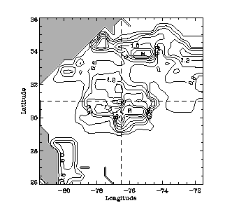
Figure 5. The AMSU-A derived cloud liquid water path (every 0.3 mm) at 0000 UTC 26 August 1998. The intersection of the two dash lines is the hurricane center. Shadings denote the land area.
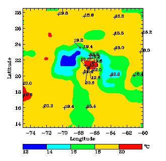
Figure 6. Comparison of the AMSU-retrieved temperatures (color shadings) to the GPS dropsonde measurements (marked next to +) at 850 hPa at 0000 UTC 22 August 1998.
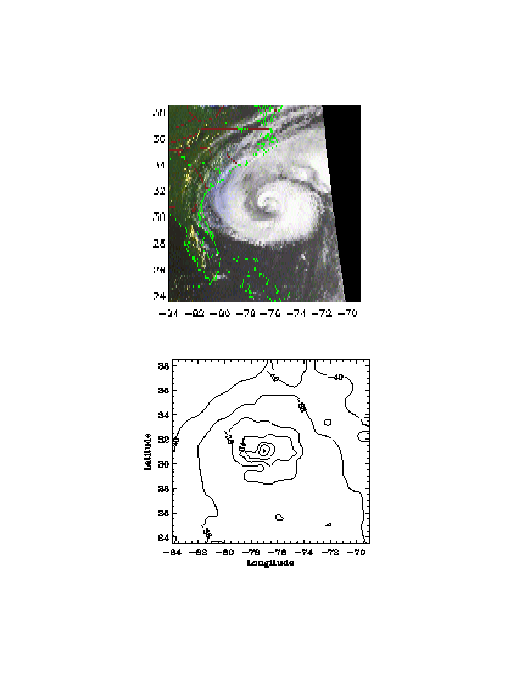
Figure 7. (a) NOAA-12 AVHRR infrared imagery at 23:19 UTC 25 August 1998. (b) The AMSU-retrieved 250-hPa temperatures (every 2 0C) at 0000 UTC 26 August 1998.
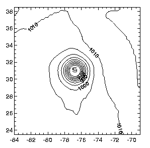
Figure 8. The sea-level pressure (every 5 hPa) distribution empirically obtained from Eq. (4) for Hurricane Bonnie at 0000 UTC 26 August 1998.
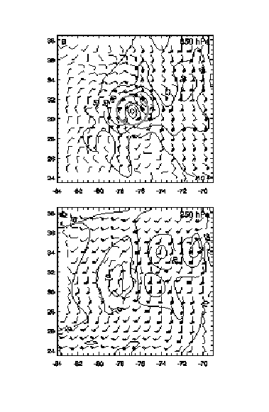
Figure 9. The AMSU-retrieved balanced horizontal winds at 0000 UTC 26 August 1998 at (a) 850 hPa; and (b) 250 hPa. Solid lines are isotaches at intervals of 5 m s-1. The shaded circle in (a) denotes the RMW from the retrieved winds. A full barb is 5 m s-1.
Figure 10. Vertical cross section of the tangential winds, at intervals of 5 m s-1, obtained from (a) the AMSU-derived temperatures given in Fig. 4b; and (b) the NCEP global temperature analysis at 0000 UTC 26 August 1998.
Figure 11. As in Fig. 4b but at 0000 UTC 22 August 1998 along (a) LON=67.50W; and (b) LAT=210N.
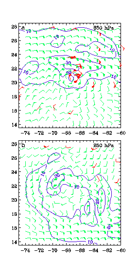
Figure 12. As in Fig. 9 but at 0000 UTC 22 August 1998. Plotted in green and red are the horizontal winds retrieved from the AMSU-A and obtained from the GPS dropsonde measurements, respectively. Blue lines are isotaches at intervals of 5 m s-1.
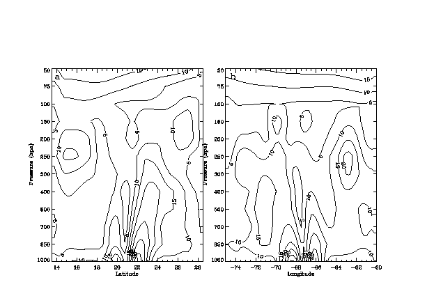
Figure 13. As in Fig. 10a but at 0000 UTC 22 August 1998 along (a) LON=67.50W; and (b) LAT=210N.
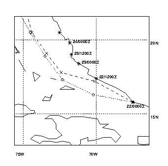
Figure 14. Tracks of Hurricane Bonnie from the best track analysis (solid), the control (dashed) and sensitivity (dotted) simulations. The positions of the storm center are given every 6 hour.
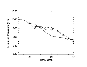
Figure 15. Time series of the minimum central pressure (hPa) from the observed (solid), the control (dashed) and sensitivity (dotted) simulations between 0000 UTC 22 and 0000 UTC 24 August 1998.
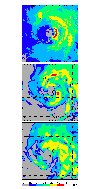
Figure 16. Radar reflectivity from (a) NOAAs WP-3D reconnaissance aircraft at 2130 UTC 23 August at the 4544-m altitude; (b) the control simulation; and (c) the sensitivity simulation, at 2200 UTC 23 August near 480 hPa. The three panels have the same color scale and the same domain size of 360 km x 360 km.