Understanding Ocean Salinity
Introduction - "Why salt?"
For centuries we've looked at clouds to help us understand and predict the weather.
The old saying, "Red sky at morning, sailors take warning..." is a reference to the type of clouds that we now call altocumulus -- high puffy clouds that glow red in the light of the rising Sun.
The presence of altocumulus clouds indicates that there is both moisture and instability high in the atmosphere -- conditions which often enable small, low clouds to grow into large, dangerous stormclouds as the atmosphere heats up during the day.
In a sense, ancient sailors used the position and appearance of clouds to "see" the current state of the atmosphere and predict what it would be doing later in the day.
Modern scientists study salt in the ocean in the same spirit that ancient sailors studied clouds in the sky because salinity allows us to "see" the Earth's hydrological cycle. Tiny variations in the ocean's salinity clue us in to changes of precipitation, evaporation, stream runoff, ocean currents, and their interactions.
Understanding the changes in these interactions is important because the frequency and intensity of weather events is directly dependent upon the hydrological cycle. While we experience most of these weather events on land, where we have ample sources of weather data, the largest movements of water and energy within the cycle happen over the Earth's oceans.
Collecting and processing oceanographic data is critical to improving our ability to both predict weather events and infer how such events may be influenced by Earth's changing climate.
Our work focuses on understanding the role that geostrophic turbulence plays in oceanic circulation using fluid dynamical models to see the tiny variations of salinity within the ocean.
Scientific Modelling
Many people have a fuzzy idea of what is meant when scientists talk about a scientific model.
This is probably because the term seems as if it means different things in different contexts.
Perhaps the best known scientific model is the model of the solar system, with the Sun in the center and the planets, their moons, the asteroid belt and planetoids (sorry Pluto!) orbiting around it.

This current model of the solar system is the cumulative result of hundreds of years of scientific observation. In this case, the word model can mean a visual depiction of how the Sun & planets interact in a way that is both consistent with our understanding of physics (theory) and our astronomical observations (data).
But our model of the solar system can also mean something slightly different...
While it is easy to imagine that each planets' orbit around the Sun is governed completely by the pull of the Sun's gravity, in reality the story is a bit more complicated because every single body of mass in the universe gives a gravitational tug to every single other body of mass in the universe.
So while the Earth seems to orbit the Sun almost in a circle, its orbit noticeably varies from a circle because it is tugged on by the Moon, Mercury, Venus, Mars, the asteroids, gas giants, and even distant stars.
Calculating the Earth's orbit around the Sun suddenly seems a bit more complicated. We have, using Newton's Laws of Motion, the mathematical tools to predict the Earth's orbit around the Sun if we pretend that there is nothing else in the universe except for them.
But if we merely try to take the gravitational effect of the moon into account the equations for predicting the orbit of the Earth about the Sun become too complicated to solve with pencil and paper. The exact solution to these equations has eluded scientists and mathematicians since Isaac Newton first posed the problem in 1687.
In fact, two hundred years after Newton first posed the problem, a pair of mathematicians named Ernst Bruns and Henri Poincaré proved that an exact, general solution to this problem does not exist.
To overcome our inability to solve these equations, scientists have developed other techniques to solve these equations using computers. We can convert physical laws into a set of computer code, commonly known as a scientific model. If we feed the initial positions and velocities of the Earth, Moon, and Sun to this model we can generate a remarkably precise calculation of the Earth's trajectory around the Sun. Adding in the positions and velocities of all of the other planets makes our model more complicated but results in an even more precise calculation.
Models in Meteorology
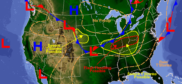
The class of scientific models that people probably use most in their day-to-day lives are weather forecast models. These models are the ones that may tell you tomorrow will have a 30% chance of showers with winds in the 5-10 mph range.
The process by which these predictions are generated is fascinating (to some at least!). Scientists start by taking laws of physics (theory) such as Newton's Laws of Motion, the principle of conservation of mass, thermodynamic equations, etc. and manipulate these equations so that they can be applied appropriately to the Earth's atmosphere.
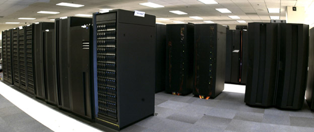
These mathematical manipulations result in equations that are much more complicated than those used in our model of the solar system, so scientists then translate these equations into superfast computer code and run these computer programs on massive super computers.
Unlike our solar system model which uses the initial positions and velocities of the planets as input, these weather models take observations from weather balloons, satellites, radar and airplanes (data) as their input and output the weather forecast.
In this way, weather models are very similar to our model of the solar system: they serve as a bridge between theory and data. They also help us to both make predictions (forecasts) and visualize complex systems so that we can understand them better.
Models in Oceanography
Oceanographic models are very simliar to meteorological models. They take the same physical laws as those used in meteorology but alter them in a slightly different fashion so they can be applied appropriately to the ocean instead of the atmosphere.
You can probably come up with one of the key differences that scientists use when constructing an atmospheric model versus an oceanographic model: ocean models have higher density since salt water is more dense than air.
Meteorologists and oceanographers use many of the same tools for data collection (satellites, ocean buoys, weather balloons, etc.) and prediction (numerical models that integrate the laws of physics) because both fields are subsets of a larger area of study known as geophysical fluid dynamics.
Salinity
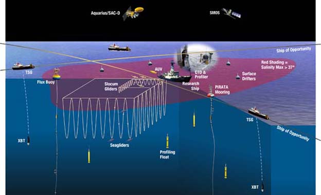
Now that you're familiar with the process that generates the daily weather map, you might be curious to understand how we generate a salinity map of the world's ocean. What are the tools scientists use to study the ocean in place of the weather balloons, satellites, radar and airplanes that meteorologists use to study the atmosphere?
Aquarius
Aquarius is a NASA satellite mission that aims to map sea surface salinity. Its mission, according to the Aquarius website:
SPURS
SPURS is a field campaign that complements the research goals of the Aquarius mission by capturing surface and subsurface data from a section of the subtropical Atlantic ocean.
You can learn more about the field campaign by visiting the SPURS website.
Salinity Modelling
Two types of models are employed to complement the science missions of Aquarius and SPURS: regional models -- which are run to model a small section of the ocean -- and global models -- which provide planetary scale simulations of sea surface salinity.
Regional
The Regional Ocean Modelling System (ROMS) is used by SPURS scientists to provide realtime forecasts and hindcasts of sea surface salinity conditions for the section of the Atlantic Ocean under observation during the field campaign.
Global
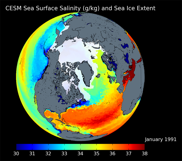
Our team focuses on the global modelling of salinity. We employ the Parallel Ocean Program to run an ultra hi-res (1/10° x 1/10°) ocean model. Such high resolution permits our model to allow the formation of what is known as "geostrophic turbulence." The analagous phenomena in the atmosphere should be very familiar: atmospheric cyclones arise from "baroclinic instability," a class of turbulence that occurs at much larger scales in the atmosphere than it does in the ocean.
Visualization
To see a high-definition (6.9 MB) visualization of the Parallel Ocean Program, click on the image below.
Team Members
Members of the Aquarius Ultra Hi-Res Salinity Modelling team are Professor James Carton, Dr. Frank Bryan, and Ben Johnson.
For questions or comments about this site, please contact Ben Johnson by emailing bjohnson 'at' aosc 'dot' umd 'dot' edu.